
![]()
![]()
![]()
![]()
![]()
![]()
![]()
![]()
![]()
![]()
Maps & Directions
barton park | gene campbell | lewis park | orwall park | opponents fields | other places
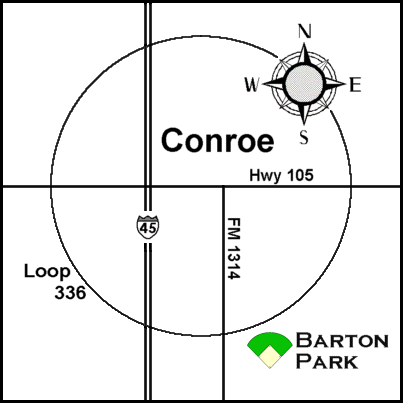
Barton Park [ jump to directions ] [ top ]
2500 South Loop 336
Conroe, Texas 77302
[ click image to go to map on bing.com ]
Directions to Barton Park / Conroe
- From Points South: Take I-45 north to Conroe. Exit South Loop 336. When you come off the ramp, you will want to stay to the right. Come down to the light and take a right to get onto South Loop 336 heading east. Go about two miles and through the light at FM 1314. Barton Park is located on the right about a 1/2 mile past FM 1314. Turn right into the parking area. The High School and Junior High fields will be to the left as you enter the parking area.
- From Points North: Take I-45 south through Conroe. Exit South Loop 336 (this is the second Loop 336 exit when coming from the north). Turn left at the second light (there are two lights together) to get onto South Loop 336 heading east. You will go just over two miles and through the light at FM 1314. Barton Park is located on the right about a 1/2 mile past FM 1314. Turn right into the parking area. The High School and Junior High fields will be to the left as you enter the parking area.
- Field Notes: The Falcons High School team will typically play its home games on the BLUE field (to the left as you come up the walkway). The Junior High team usually plays on the GREEN field (which is just beyond the Blue field). Practice and training sessions are most often held on the Green field as well. The YELLOW and RED fields are used occasionally as well.
- From Points North: Take I-45 south through Conroe. Exit South Loop 336 (this is the second Loop 336 exit when coming from the north). Turn left at the second light (there are two lights together) to get onto South Loop 336 heading east. You will go just over two miles and through the light at FM 1314. Barton Park is located on the right about a 1/2 mile past FM 1314. Turn right into the parking area. The High School and Junior High fields will be to the left as you enter the parking area.
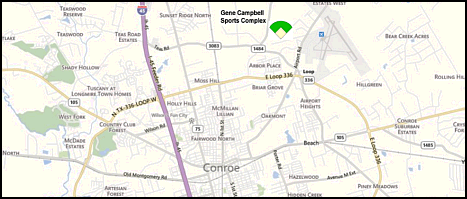
Gene Campbell Sports Complex (CAYB) [ jump to directions ] [ top ]
3200 FM 1484
Conroe, Texas 77303
[ click image to go to map on bing.com ]
Directions to Gene Campbell Sports Complex (CAYB) / Conroe
- From Houston and Other Points South: Take I-45 north through Conroe. Exit FM 3083 (Teas Road). Turn right on FM 3083. Go approximately 2.5 miles (past Hwy 75 and over RR tracks) to FM 1484. Turn left on FM 1484. Park is on the right.
- From Huntsville and Other Points North: Take I-45 south to Conroe. Exit FM 3083 (Teas Road). Turn left on FM 3083 and go over the freeway. Go approximately 2.5 miles (past Hwy 75 and over RR tracks) to FM 1484. Turn left on FM 1484. Park is on the right.
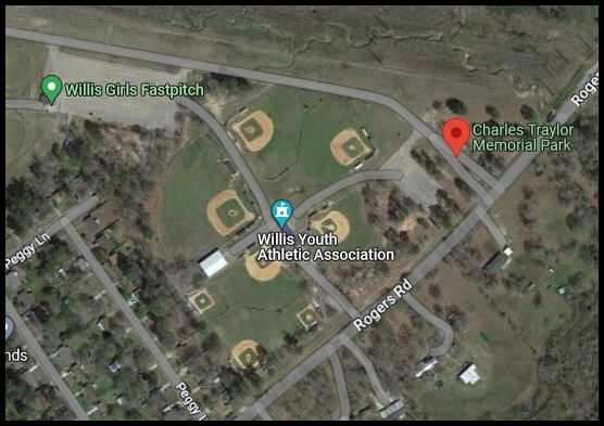
Charles Traylor Memorial Park (WYAA) [ jump to directions ] [ top ]
13551 Rogers Road
Willis, Texas 77378
[ click image to go to map on Google ]
Directions to Charles Traylor Memorial Park (WYAA) / Willis
- From Houston and Other Points South: Take I-45 north to Willis. Take Exit 94 and head east (right) on FM 1097 / West Montgomery St. Go approximately 3/4 mile and turn left on Hwy 75. Go 4-1/2 blocks and turn right on Rogers Rd. Go about 1 mile to fields on left.
- From Huntsville and Other Points North: Take I-45 south to Willis. Take Exit 94 and turn left to cross over freeway and head east on FM 1097 / West Montgomery St. Go approximately 1 mile and turn left on Hwy 75. Go 4-1/2 blocks and turn right on Rogers Rd. Go about 1 mile to fields on left.
Lewis Park [ jump to directions ] [ top ]
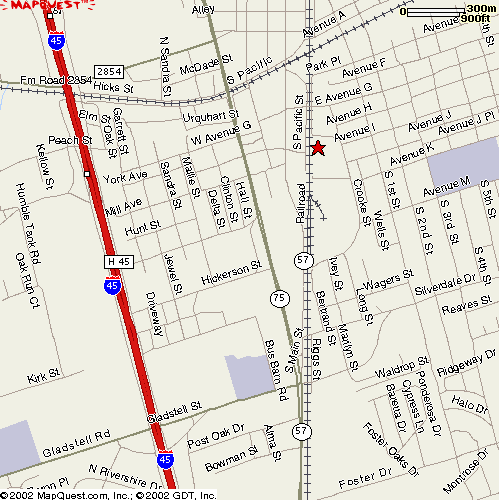
Directions to Lewis Park / Conroe
- From Points South: I-45 North. Take the Gladstell Street exit. Follow the feeder and turn right just before the overpass; stay straight to merge onto Gladstell heading east. Go through light at South Frazier (75), and proceed over the RR tracks. Gladstell will curve around and become Silverdale Road. Go to four-way stop and turn left (north) on 1st Street. Go past 1st Street Park (which is on the right), and turn left on I Street. I Street dead-ends at Lewis Park. Jog right and then left again to get to parking lot. There is only one field.
- From Points North: I-45 South. Take the Hwy 105 exit. Turn left at light to head east on 105 (under the freeway). Go through downtown Conroe and cross the RR tracks. Turn right at light onto 1st Street. Turn right on I Street. I Street dead-ends at Lewis Park. Jog right and then left again to get to parking lot. There is only one field.
Orwall Park [ jump to directions ] [ top ]
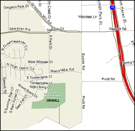
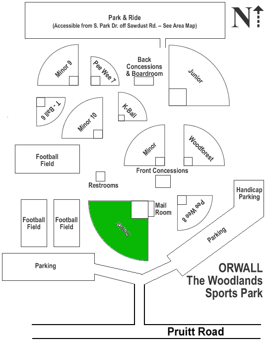
Directions to Orwall Park / The Woodlands
- From Points South: Take I-45 north to The Woodlands. Exit Rayford-Sawdust (Exit 73). Stay left on the feeder and do a U-Turn under 45 to get on the southbound feeder. Move all the way to the right and turn right on Pruitt Road (just past the Mobil gas station). Go to dead end and turn left to continue on Pruitt (it's called Budde Road to the right). Go exactly 7/10 of a mile and turn right into the park complex (1130 Pruitt Road). The Senior field is straight ahead, the first field you come to as you enter the parking area.
- From Points North: Take I-45 south to The Woodlands. Take Exit 72-A (just past Rayford-Sawdust) and immediately move to the far right lane. Turn right on Pruitt Road (just past the Mobil gas station). Go to dead end and turn left to continue on Pruitt Road (it's called Budde Road to the right). Go exactly 7/10 of a mile and turn right into the park complex (1130 Pruitt Road). The Senior field is straight ahead, the first field you come to as you enter the parking area.
Opponents Fields [ top ]
Alden Bridge Sports Park (The Woodlands) [ map ]
4751 TX-242, The Woodlands, TX 77382
Phone: (281) 210-3800
Allen Academy (Bryan) [ website ] [ map & directions ]
From Conroe: Take Hwy 105 west to Navasota. Turn right (north) on Hwy 6. As you come into College Station, stay on the Hwy 6 Bypass. Go approximately 5 miles to Briarcrest Drive. Take Briarcrest Exit. Take a right on Briarcrest Drive. Next stop light - Allen Academy in on the corner across the street on the right. You can go straight at signal light and turn right in first drive.
Physical Address: 3201 Boonville, Bryan, TX 77802
Phone: 979-776-0731.
Alpha Omega Academy (Huntsville) [ website ]
From Conroe, take I-45 north into Huntsville. Exit Hwy 30 and go West (toward Bryan/ College Station). Go about three miles. Campus/Field is on left . . . before the Fairgrounds.
Anderson Park (Houston) [ map ]
(Occasional home field for Houston Power)
Physical Address: 5701 Beverly Hill St., Houston, TX 77057
Baseball USA [ website ] [ map ]
(Home field for Houston Christian High School and St. Francis Middle School)
Take I-45 South to Sam Houston Toll Road. Take Toll Road West to Hammerly Exit. Take U-Turn under bridge to get on the northbound feeder. Stay on feeder. Turn right into Baseball USA. Field #1 is the first field on the left.
Physical Address: 2626 W. Sam Houston Parkway North, Houston, TX 77043
Phone: 713-690-5055 / 713-690-5564
Bay Area Christian School [ map ]
Physical Address: 4800 W Main St, League City, TX 77573
Brenham Christian [ map ]
Directions are on hold until we can better confirm the location of the park.
Briscoe Junior High
Games played at Foster High School in Richmond, Texas [ map ]
Physical Address: Foster High School, 440 FM 723, Richmond, TX 77469
Contact: Bruce Stephens Phone: 281-263-3912
Directions: From Beltway 8 and Hwy 59 South: Take Hwy 59 south. Exit to Hwy 6 West. Continue Hwy 6 West (approx 2 miles) to Left on Hwy 90A West. Continue Hwy 90A West (approx 5 miles) to Right on FM 359. Continue FM 359 (approx 5 miles) to Left on FM 723. Foster High School is on immediate left. Baseball field is in the back of the campus.
BVCHEA Mustangs (Bryan / College Station)
Games played at several locations, including:
-
Brazos Valley Bank Ballpark (Bombers Baseball Field) [ map ] [ website directions ]
Directions: From Conroe, take Hwy 105 west to Navasota. Take Highway 6 north into College Station. Exit Texas Avenue and remain on Texas Ave north through College Station. Go past the college (Texas A&M Univ.). Take a left on Carson Street (which will be after Howard Street). Go through the light at South College Avenue. Brazos Valley Bank Ballpark will be on your left just before the railroad tracks.- Alternate Directions: From Texas Avenue, take a left on 2818 (West Loop / Harvey Mitchell Pkwy). [Note that you can also stay on Highway 6 and exit at 2818. Either way, go left on 2818]. Take the loop all the way around College Station. Some of the roads you will pass will be: Wellborn Rd., George Bush Dr., University Dr., and Villa Maria. Once you have passed Villa Maria, go about 1/2 mile and turn right on Turkey Creek Road. At the light, go straight and Turkey Creek Road will become W. Carson St. The field is on the right, after the RR tracks.
Caldwell High School - Caldwell, Texas [ map ]
550 Co Rd 307, Caldwell, TX 77836
Carrolton Storm (TACA) [ website ]
Parks that TACA plays at include:
- McInnish Baseball Fields [ map ]
2340 E Sandy Lake Rd
Coppell, TX 75019 - Z-Plex Texas Sports Village [ map ]
4220 E Melissa Rd
Melissa, TX 75454
Central High School - Central, Texas [ map ]
From Cleveland: Take US 59 North to Lufkin. Turn left on Loop 287 (S. John Redditt Drive). Go about 5.5 miles on Loop 287. Turn left on US 69. Go about 5.5 miles on US 69 into Central. School is on right. Baseball field is in back.
Cleveland High School - Cleveland, Texas [ map ]
NOTE: The new, all-turf field is located behind the school, by the tennis courts. NO METAL CLEATS, SEEDS, or GUM. Flats, turf shoes, or molded cleats are fine.
From Conroe: Take Hwy 105 east toward Cleveland. Go under US 59 and continue to end. Turn left at light onto South Washington Avenue (105 and 573). Go to next light and turn right on West Houston Street (105 and 321). Continue on W. Houston (road name changes to E. Houston St.) for approximately 1.2 miles. Turn right onto Charles Barker Ave. (school will then be on your left). Turn left onto Truman St. Turn left into parking area. Field is on the right.
CHEF Patriots - Baton Rouge, LA
Games being played in Lake Charles, LA
- Brentwood Park
- 1601 Illinois St. Lake Charles, LA 70607
Concordia Lutheran High School [ website ] [ maps & directions ]
- 700 E. Main
- Tomball, TX 77375
Conroe Knights / Venom (Select Teams) [ map ]
- 15230 Rabon Chapel R.
- Montgomery, TX 77316
From I-45 in Conroe: Head west on FM 2854. Go about seven miles. Go under Fish Creek Thoroughfare. In just under a mile, you will turn right on Rabon Chapel. Fields are on the right. (you can see them from FM 2854)
Covenant Christian School [ website ] [ map ]
Covenant Christian School is part of the Conroe Bible Church complex, located on the southbound side of I-45 between League Line Road and FM 830 (north of Conroe). From points south (Conroe proper), take I-45 north. Exit FM 830 (the exit after League Line Road). Turn left onto FM 830 and cross the freeway. Turn left on the other side of bridge to get on southbound I-45 feeder. Stay on the feeder. Follow the feeder almost all the way back to League Line Road. Campus is on the right (duh) and the field is in the back, to the left.
Covenant Prep - Kingwood [ map ]
Covenant Preparatory School (formerly Northeast Christian) plays its Junior High home games at Deer Ridge Park in Kingwood. From 69/59, go east on Kingwood Dr. Turn right on Woodland Hills Drive. Go approximately one mile and turn right on Hundred Oaks Dr. Fields are on the right, but "which field" varies. May be at the end.
Cypress Christian School (CCS) [ website ] [ map ]
The CCS campus is located at 11123 Cypress N. Houston Rd. near Jones Rd. in northwest Houston. From Conroe, take I-45 South. West on Louetta. Go past Hwy 249 (Tomball Pkwy). Turn left on Jones Road. Go past Grant Road. Turn right on Cypress North Houston Road. School is on left. Field is in the back. (It also looks like you can take Jones Road past Cypress North Houston and turn right into a drive that takes you back to the baseball field).
Danbury High School � Danbury, Texas
From Houston: Take 288 south toward Angleton. Exit Business 288. Turn left at light to get on Business 288, heading south. Go about 3 to 4 miles and turn left on 523. Go about 2-1/2 miles and turn left on 35, heading north toward Danbury. Go to second blinking light and turn right on Spur 28. Go about a mile and turn left on Quail Ridge Rd. (530). Field is the last field on the left in Little League park.
NOTE: This is not necessarily the quickest route, but according to the coach, it is the easiest.
Dallas Angels (HSAA) [ website ] [ map ]
- Breckinridge Park
- 3555 Brand Rd, Richardson, TX 75082
Coming from Houston, you can take the Renner exit from Hiighway 75 and head east (right) on Renner Road to the park (corner of Brand and Renner). This route avoids tolls. Your GPS may send you to the next exit (George Bush Tollway) from 75. Head east. Take the Renner Exit and turn left.
(Brand Street entrance is closer to parking).
Dallas Spartans [ website ] [ map to field ]
Known as both Dallas Christian Home Educators (DasCHE) and Southwest Dallas Homeschool Sports Association (SWDHSA), the Dallas Spartans play their home games at:
- Waxahachie Sports Complex
- 151 Broadhead Rd.
- Waxahachie, Tx. 75165
- 151 Broadhead Rd.
Diboll High School [ map ]
Field is in the old Orchard Park in Diboll
Take US 59 North from Houston. When you come into Diboll, go through the first signal light. Look for First Bank and Trust of East Texas. You will make a right turn just past the bank onto Durham St. Durham becomes Hall. Road will split. Stay on main road which becomes Stubblefield. Baseball field is on the left.
ECCHO Eagles (Homeschool) [ map ]
Valley Ridge Park / Porter Field
2850 Park Ridge Dr
Cedar Hill, TX 75104
Emery Weiner School [ map ]
9825 Stella Link Road
Houston, TX 77025
Faith West Academy (Katy) [ website ] [ map ]
2225 Porter Road, Katy, TX 77493
From Houston: Take I-10 West past Beltway 8 and Highway 6. Exit Grand Parkway (U.S. 99). At the light, take a right (north) and go until it dead ends. At this light, Franz Road, take a left (west). Go to the 3rd light which is Porter Road and take a right (north). The school is on the left hand side. Use the third driveway.
First Baptist - Pasadena [ website ] [ map ]
7500 West Fairmont Parkway, Pasadena, TX 77505
Fort Bend Christian Academy [ map ] [ website ]
The FBCA High School teams play at the school field, located at:
- Ft. Bend Christian Academy
- 1250 7th St
- Sugar Land, TX 77478
- 1250 7th St
The FBCA Middle School teams play their home games either at the school (see above) or at:
-
First Colony Little League Park (Sugarland) [ map ]
3222 Austin Parkway � Sugarland, Texas � 77479
Directions: Take 45 South into Houston and pick up 59 South to Sugarland. Exit Williams Trace Blvd. Turn left on Williams Trace Blvd (under 59). Go past Lexington Blvd. and Highway 6. Turn left on Austin Parkway. Fields are on right. Use second entrance.
Ft. Worth Riders [ map ]
For the 2016 double-header, we will be playing at:
-
Cross Timbers Park
7680 Douglas Rd
North Richland Hills, TX 76182
Franklin Ranch Community Park [ map ] [ park map ] [ website ]
The Franklin Round Robin games are played here:
- Franklin Community Ranch
- 2925 FM 46
- Franklin, TX 77856
- [ Important Park Rules ]
- 2925 FM 46
Grace School [ map ]
Physical Address: 10219 Ella Lee Lane, Houston, TX 77042 � Phone: (713) 782-4421
I-45 South to Beltway 8. Take Beltway 8 West. After passing the I-10 interchange, it looks like the best route is to exit Westheimer and then u-turn under the freeway to head back north on the Beltway 8 feeder. Turn right into school parking lot (if you miss it you can turn right on Ella Lee Lane). Follow parking lot to field.
Hempstead High School [ map ]
Physical Address: 801 Donoho Street, Hempstead, TX 77445 � Phone: (979) 826 -3331
From Houston, take 290 west toward Austin. Go through Waller. Exit FM 1488. Turn left on FM 1488. Turn right on Bus. 290. Turn left on 3rd, 4th, or 5th street. Go to end. Turn right on Donoho. Field is on left.
Holy Trinity Episcopal School [ website] [ map ]
Physical Address: 11810 Lockwood Rd, Houston, TX � Phone: (281) 459-4323
From points north, go south on I-45 or US 59 to Beltway 8 / Sam Houston Parkway. Go east on Beltway 8. Turn right on North Lake Houston Parkway (this is after Beltway 8 curves to the right and starts heading south). Turn left on Lockwood Road. School is on left.
Houston Eagles (HCYA) [ website ]
Parks that HCYA plays at include:
- Ben Briar Park � 1115 Bennett Dr � Pasadena, TX 77503 [ map ]
From the north, one route is to take Beltway 8 around the east side of Houston. Go past 225 (Pasadena Freeway) and take the first exit (Ramsey/St Augustine). After the tollbooth, get all the way to the right and make the very first right from the feeder on Crawford. Go to end. Turn right on Bennett. Field is on right.An alternate route would be to take Loop 610 around the east side of Houston to 225, and 225 (east) to the Beltway 8 feeder (south). Stay on the feeder and follow the directions from above. You avoid the toll this way also.
- Memorial Park (Houston) [ map ]
The new location for the baseball field at Memorial Park is:
- 1001 E Memorial Loop Dr
- Houston, TX 77007
It is across the street from the driving range. If you enter the park from Westcott, it is the first field on your right. There is a parking fee of $1 for 3 hours.
- 1001 E Memorial Loop Dr
- Missouri City Little League, High School field
(Near) 200 Lantern Trail Ct, Missouri City 77459 [ map ]
Note that it says "Near". Looks like you need to go past the softball fields and around a lake to get to the baseball fields. - Mont Belvieu City Park, 10900 Eagle Drive (which is FM 3180), Mont Belvieu, TX 77580 [ map ]
The HCYA team plays on the senior field at this complex, which is just past Barbers Hill High School (coming from I-10). Exit 1-10 at FM 3180 (also labeled Eagle Drive) and go north over I-10. You will pass the Barbers Hill schools on your right. Shortly past the schools there is road construction which will take the four lane road down to two lanes. Just past this you will see the park entrance on the right. The field is the first one on the left. - Strawberry Park / Pasadena [ map ]
Take I-45 South through Houston. Go past Loop 610 on the south side. Exit College Ave. Turn left (east) on College Avenue to go under I-45 and through South Houston. Go past S. Shaver Street and Lafferty Road. Turn left on Strawberry Road. Field is on the left. - South Campus Sports Association / Houston [ map & directions ] [website ]
Located just off Loop 610 at the intersection of Stella Link and W. Bellfort. There are a number of ways to get there from Conroe (all beginning with I-45 south, of course), but one way is to simply take Loop 610 West around the west side of Houston. Take the Stella Link exit and turn right (south) on Stella Link. The park will be on the left. The high school field is the furthest from the entrance.
Houston Power
Usually played at:
- Memorial Park (Houston) [ map ]
The new location for the baseball field at Memorial Park is:
- 1001 E Memorial Loop Dr
- Houston, TX 77007
It is across the street from the driving range. If you enter the park from Westcott, it is the first field on your right. There is a parking fee of $1 for 3 hours.
- 1001 E Memorial Loop Dr
Hudson High School (Lufkin) [ website ] [ map ]
Physical Address: 6735 Ted Trout Dr, Lufkin, TX 75904 � Phone: (936) 875-9247 (school)
Huntington High School (Lufkin) [ website ] [ map ]
Physical Address: 952 S Gibson St, Huntington TX 75949 � Phone: (936) 876-4150 (school)
John Cooper School [ website ] [ map ]
From Conroe: South on I-45 to Hwy 242 (Exit 79). Travel west on 242 for 1.5 miles. Turn left on Gosling Road. Turn right on Woodlands Parkway. Turn left at traffic light onto John Cooper Drive. Turn left into the school. Take a quick right. Go 100 yards and turn left. Go to end of parking lots. Park by the two gymasium buildings. Softball and baseball fields are "behind the gyms". There are no restrooms at the field; use the restrooms at the gyms.
(Monsignor) Kelly High School (Beaumont) [ website ] [ map ]
Physical Address: 5950 Kelly Drive, Beaumont, TX 77707 � Phone: (409) 866-2351
KIPP Academy [ website ]
Physical Address: 10711 KIPP Way, Houston, TX 77099-2675 � Phone: (832) 328-1051
Take Hwy. 59 south through Houston. Exit at the Beltway 8 Frontage Road. (Do not get on the Toll Road.) Turn right onto the northbound feeder of the Beltway 8 Frontage Road. The first light is Bissonnet. Make a u-turn there under the Beltway. Take the first right (after McDonald�s which is on the corner of the Beltway Frontage Road and Bissonnet) onto KIPP Way. KIPP Academy is on the left, after the industrial park.
Lamar Junior High
Games played at Lamar High School in Rosenberg, Texas [ map ]
Physical Address: Lamar High School, 4606 Mustang Ave., Rosenberg, TX 77471
Contact: Keith Cox Phone: 281-513-5667
Directions: 59 South to FM 762 Exit for Richmond. At the end of the exit ramp turn RIGHT onto FM 762. At the first traffic light (George Memorial Library will be on your right) take a LEFT. At the second traffic light, the road will split - Stay to the RIGHT. This is FM 1640 (also known as Avenue I). You will see Traylor (Football) Stadium on your right. Turn RIGHT at your first opportunity after passing the Football Stadium. You can see the baseball field from Avenue I. Total distance from 59 to the field is 3-4 miles.
Lee High School (Baytown) [ map (you will need to zoom out to get a better view) ]
From Conroe: I-45 South to Beltway 8. Beltway 8 east to I-10. I-10 East to Baytown. Take Exit 788 (Hwy 330). Exit Decker Drive; stay straight to remain on Decker Drive, which becomes Market St. as it makes a big right had curve. Go past Lee College, then Bicentennial Park on left. Take a left into first entrance past Bicentennial Park into the baseball field parking lot.
Legacy Prep [ website ] [ map ]
Physical Address: 9768 Research Forest Drive � The Woodlands, Tx 77354
Phone: (936) 337-2000 (school)
Liberty High School [ map (you will need to zoom out to get a better view) ]
Physical Address: 2615 Jefferson Drive, Liberty, TX 77575
Contact: Josh Sadler, coach 936-346-6707
Games are played at the city park on Cook Road, not at the school.
Directions (from Conroe): Take FM 3083 South from Conroe. FM 3083 becomes FM 1485. Continue all the way to New Caney and cross Hwy 59. FM 1485 dead-ends at the railroad track. Turn right on Loop 494, then left to continue again on FM 1485. FM 1485 becomes FM 2100. When you get to Huffman, turn left on FM 1960. FM 1960 ends at Dayton. Turn right on FM 321 (North Cleveland Street), then turn left on Hwy 90. Hwy 90 will take you into Liberty. Turn left on Loop 227 (N. Main St.). Go to the 5th signal light and take a left on Cook Rd. This will take you into the park. Once in the park veer to the left and stay on the main road to the back side of the park. You will see Liberty's dugouts that are black with a large P on the back.
Alternate Route: Take 105 East through Cleveland (there's a left-right jog in Cleveland and another left on the other side of Cleveland to stay on 105). Continue on 105 to Moss Hill. Turn right (south) at Moss Hill on FM 146. Take 146 into Liberty. When you come into Liberty, do not turn left to stay on 146. Instead stay straight and get on Loop 227 (N. Main). Turn right on Cook Rd. This will take you into the park. Once in the park veer to the left and stay on the main road to the back side of the park. You will see Liberty's dugouts that are black with a large P on the back.
Lutheran North
From Conroe: South on I-45 to Loop 610 in Houston. Take Loop 610 West to N. Shepherd. Exit and turn right (north) on N. Shepherd. Go to first signal light and turn left (west) on 34th Street. School is on the right at next signal light. Turn right at that light (Alba). Field is on the right, by the railroad tracks.
Lutheran South Academy [ map ]
Address: 12555 Ryewater Dr., Houston, TX 77089
Magnolia Youth Park [ map & directions ] [ field designations ]
Magnolia Youth Park is another location for Spring Klein Youth Baseball and Spring Klein Sports Association. It is where we are playing one of our 15u league games in 2022.
- 31660 Sugar Bend Dr
Magnolia, TX 77355
Memorial Park (Houston)
Several teams will occasionally schedule at this location
- Memorial Park (Houston) [ map ]
The new location for the baseball field at Memorial Park is:
- 1001 E Memorial Loop Dr
- Houston, TX 77007
It is across the street from the driving range. If you enter the park from Westcott, it is the first field on your right. There is a parking fee of $1 for 3 hours.
- 1001 E Memorial Loop Dr
Northeast Christian (games held at Kingwood College)
FM 1314 south to Hwy 59. Hwy 59 South to Kingwood Drive exit. Go west (right) on Kingwood Drive until it dead-ends and turn right. Turn into the first parking lot on the left. The field is located behind the parking lot on the Kingwood College campus.
Northland Christian School [ map & directions ]
From I-45, Take FM 1960 West past Kuykendahl to Torrey Chase (before Steubner-Airline). Turn left on Torrey Chase. Go through the stop sign at the first Sylvanfield. Take a right on W. Sylvanfield further down. Field is on the left.
Premier Baseball of Texas [ website ] [ map ]
- Premier Baseball Facility
20230 Cypress Rosehill
Tomball, Texas 77377IMPORTANT: These are turf fields. NO CLEATS ALLOWED.
Providence Classical School [ school website ] [ map to field ]
Providence Classical School is located at 6006 Spring Cypress Road, Spring, Texas 77379. However, they play their Junior High baseball games at Spring Klein Baseball Park, located at:
- 22430 Rothwood Rd, Spring, TX 77389
- Field #7
Rice Consolidated [ map ]
Rice Consolidated Tournament
- 1094 Raider Drive
Altair, Texas 77412
From Houston, take I-10 East. Go south (left) on Hwy 71. Turn right on ALT-90. School is on the left.
Rosehill Christian School (RCS) [ website ] [ map ]
High School games are played at the school:
- 19830 FM 2920
Tomball, Texas 77377
Junior High games are played either at the school, or at Premier Baseball (see above).
Rothwood Baseball Park [ map & directions ] [ field designations ]
Rothwood is the primary location for Spring Klein Youth Baseball and Spring Klein Sports Association. It is where we are playing our 15u league games in 2023.
- 22418 Rothwood Rd
Spring, TX 77389
Salem Lutheran School [ website ] [ map ]
From I-45, take FM 2920 west through Tomball. Turn right on Lutheran Church Road (the 3rd light after FM 249). Go approximately one mile. School is on the left. Baseball field is in the back.
Schulenburg Sports Complex
2007 Stanley Krist Memorial Tournament (March 8-10), hosted by Flatonia HS and Schulenburg HS. All of our pool play games (Thursday/Friday) are at Schulenburg.
Directions to field: From Houston, take I-10 West toward San Antonio. Exit Hwy 77 and go South. Turn left at first signal light, then go about two blocks and turn left at the stop sign. Go one block and turn right and you're there.
Lodging: We will be staying at the Oakridge Motor Inn on Hwy 77 just north of I-10. We will check in AFTER 3:00 on Thursday. In other words, we will meet at the field at 10:30-10:45, prior to our first game at noon. After the game, we will want to eat and then check into the motel.
Second Baptist [ map & directions ]
Second Baptist School is located at:
- 6410 Woodway Dr
Houston, TX 77057
Shepherd High School [ map ]
Directions to field: From Houston, take I-59 north to Shepherd. Turn LEFT onto TX-424 LOOP (S. Byrd Avenue). School is on the right about a mile in on TX-424 Loop/S Byrd Ave. Turn right into the parking lot and drive to the back of the school. The baseball field is behind the football field.
Shiner St. Paul
Games played at Shiner StarPlex
Directions to field: From Houston, take I-10 West to Schulenburg (Go through Katy, Sealy, Columbus, and Weimer). Take the first exit in Schulenburg on Hwy 77 South. Turn left (South) on Hwy 77 to Hallettsville. In Hallettsville, turn right on Hwy 90A (West) towards Shiner. Go about 12 miles and the Shiner Starplex will be on your left, 2 miles before you get to Shiner.
(Texas) Sluggers [ map ]
The Sluggers play their home games at Clark Park in Bellville.
There are several routes for getting "into" Bellville. From Houston, take I-10 West through Katy, exit Sealy and head north on 36. From 290, exit Hempstead, wiggle through town, and head south on 159. Both of these roads will become Main Street in Bellville. Stay on Main, go around the courthouse and turn right on N. Granville. The park is on the right, less than a half mile from 36.
Splendora High School
From Conroe, take FM 3083 south to Grangerland. Turn left (east) at the blinking yellow light onto FM 2090. Go 7.5 miles and school will be on the left. The baseball field is at the "old" school (now a Junior High), which is before the "new" High School. Take the first driveway (coming from the west); go through parking lot and around football field to baseball field.
St. John (Houston) [ map ]
3408 West Alabama
Houston, TX 77027
Texas Slam Field [ map ] [ website ]
Where we play Livingston HS, Hudson HS and Huntington HS
- 411 W. Park Dr. (between Livingston Memorial Hospital and Pedigo Park)
Livingston, Texas 77351
Trinity High School � 500 E. Caroline St. � Trinity, Texas [ map ]
I-45 North to Huntsville. Take Hwy 19 north to Trinity. In Trinity, turn right on Hwy 94. Go to the second flashing yellow light and turn left. Field is behind school.
Trinity Klein Lutheran School [ map ]
18926 Klein Church Rd. � Spring, TX 77379
Westbriar Middle School (Houston) [ website ] [ map ] [ map 2 ]
Westbriar MS is located at 13733 Brimhurst Drive on the west side of Houston. From Conroe, take I-45 South to Beltway 8. Take Beltway 8 West to I-10. Take I-10 west to Eldridge Parkway. Go south (left) on Eldridge (under freeway). Turn right on Brimhurst Drive. School is on the left after Park Bayou Drive. If the aerial map is correct, you should turn left on Park Bayou Drive and the field will be on the right.
Westbury Christian (Houston) [ website ] [ map ]
10420 Hillcroft St � Houston, TX � 77096
Westbury Christian plays its home games at the Westbury Christian Atheletic Complex, located at 10402 Fondren Rd, Houston, TX 77096.
West Houston Thunder
- M.A.L.L. Field (Houston) [ map & directions ]
Memorial Ashford Little League
12900 Westmere Drive � Houston, Texas
From Conroe, take I-45 south to Beltway 8 (Sam Houston Tollway). Take Beltway 8 west to I-10. Take I-10 west. Exit Dairy Ashford. Go south (left) on Dairy Ashford. Cross Briar Forest Drive. Turn right (west) on Westmere Drive. Field is located at end of Westmere on the right.
- Memorial Park (Houston) [ map ]
The new location for the baseball field at Memorial Park is:
- 1001 E Memorial Loop Dr
- Houston, TX 77007
It is across the street from the driving range. If you enter the park from Westcott, it is the first field on your right. There is a parking fee of $1 for 3 hours.
- 1001 E Memorial Loop Dr
Willis Youth Athletic Association [ website ] [ map ]
WYAA games are played at:
- Charles Traylor Sports Park
- 13551 Rogers Road
- Willis, TX 77378
- 13551 Rogers Road
World Baseball Academy (WBA) [ map ]
- 29327 S. Plum Creek Drive
- Spring, TX 77386
The Woodlands Christian Academy [ website ] [ map ]
The Woodlands Christian Academy is located at 5800 Alden Woods Drive in The Woodlands, Texas. Take I-45 to State Highway 242 (Needham Road exit). Go west on 242 approximately 3 miles to Alden Woods Drive. Turn right on Alden Woods Drive to enter the campus. The baseball field is located in the rear, behind the new gym. Park in the unpaved lot on the left (by the new gym). Walk around the left side of the new gym to the back, across the creek, and to the field. On school days, it is often helpful to arrive before 3:00 pm in order to avoid getting caught up in the carpool lanes.
World Baseball Academy (WBA) [ map ]
- 29327 S. Plum Creek Drive
- Spring, TX 77386
More opponent field directions coming soon
Other Places [ top ]
D-Bat (The Woodlands)
When weather or field conditions prohibit us from practicing on a field, we typically move indoors, currently to:
- D-Bat
- 27309 Spectrum Way
- Oak Ridge North, TX 77385
- 27309 Spectrum Way
Gosling Sports Fields (The Woodlands)
When field conditions prohibit us from practicing on a field but it's not actually raining, we may also move to the soccer fields off of Gosling Road in The Woodlands. Here is the address:
- Gosling Sports Fields
- 4055 Marsico Pl
- The Woodlands, TX 77384
- 4055 Marsico Pl
McDade Park (Conroe)
We occasionally practice here when the fields at Barton are unplayable due to a recent rain, but the day is nice and the football fields are dry enough to get some work in.
Directions: From Conroe, take FM 2854 West. Go several miles. Go under Loop 336 West and over the San Jacinto River. McDade Park will be on the right.
Top | Home | About Us | Feedback
Policy | Schedules | News | Forms | Maps | Links

|||||||||||||||||||||||||||||||||||||||||||||||| Visit our Sponsors! ||||||||||||||||||||||||||||||||||||||||||||||||
This site created by TC Concepts. Copyright 2004. All rights reserved.
All graphics, text and photos are the property of TC Concepts.